The Sanborn Map Company was a cartography business founded in 1866 that created maps of U.S. cities and towns. These maps were created for fire insurance companies to assess liability in urban areas. The maps of particular cities and towns were updated and recreated every few years and were used through the 1950s. Included in these maps are labels of social institutions such as schools, churches, clubs, and businesses, as well as street names, natural geographic features, and other elements relevant for assessing fire risk. Sanborn maps are now used by historians and urbanists to study the way in which cities changed over time.
The following slides show Sanborn Maps of Workman's Hall and its neighboring buildings in the neighborhood of Over the Rhine. Zoom in on your browser to view the detailed labels written into these maps. Click on each map to download its full-resolution image.
1891
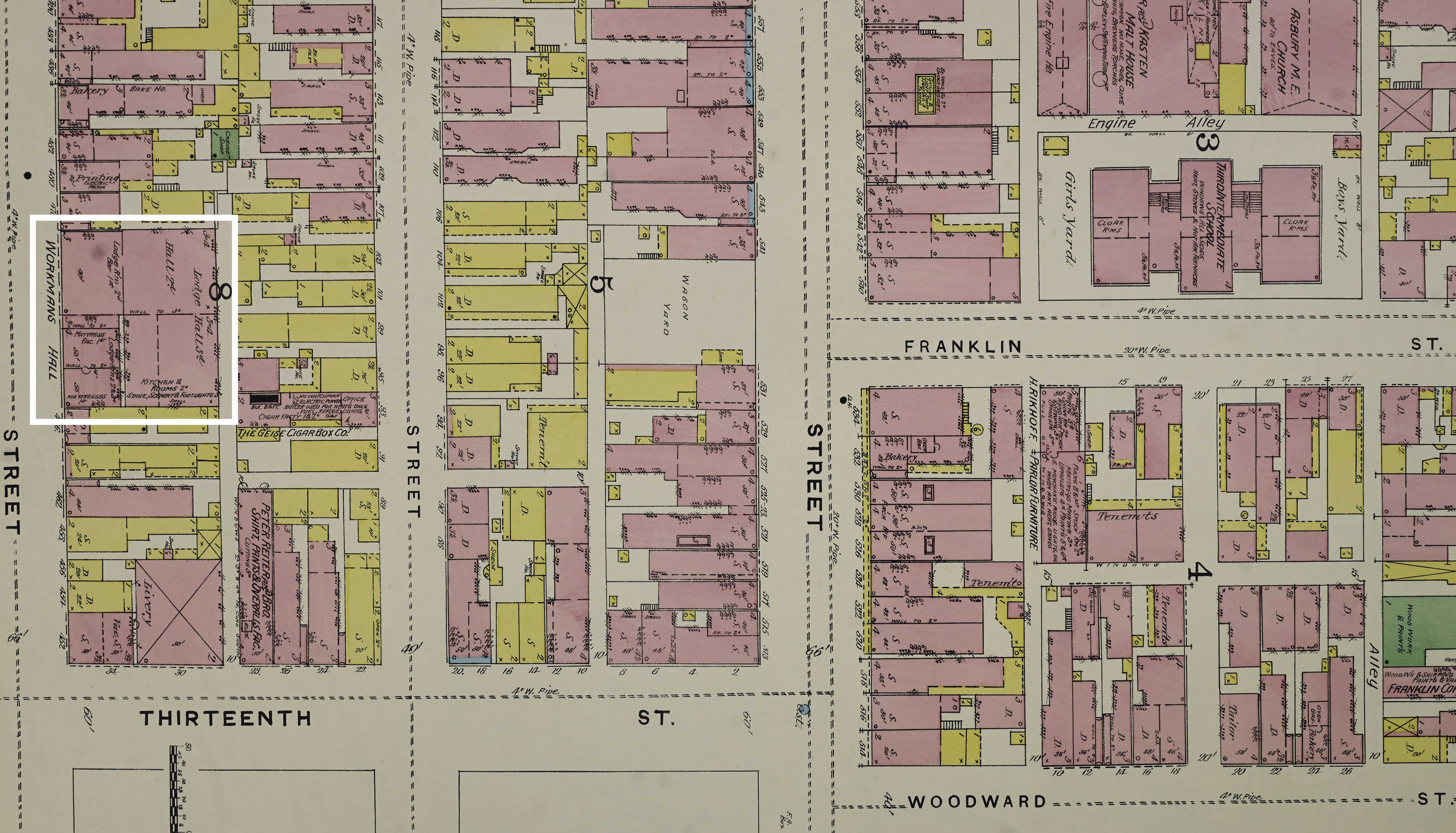
This map shows us what Workman's Hall and its surrounding area in the year 1891. In this year, the Populist Party was founded in Cincinnati, eventually eventually becoming a national party. The party used Workman's Hall as its meeting space. The party's platform included public ownership of the U.S. railroad and communication systems, a graduated income tax, public works employment in times of economic depression, initiative and referendum reforms, and calls for the president and congress to be elected by a direct popular vote.
In 1896, Workman's Hall hosted a speech given by the great socialist labor leader, Eugene V. Debs, drawing what was described by the Cincinnati Enquirer as a “monster gathering." This 1891 map includes labels for "stage, scenery, & footlights," in the room where Debs likely gave his speech.
Image source: Sanborn Fire Insurance Map from Cincinnati, Hamilton County, Ohio. Sanborn Map Company, Vol. 2, 1891. Map. https://www.loc.gov/item/sanborn06645_003/.
1904
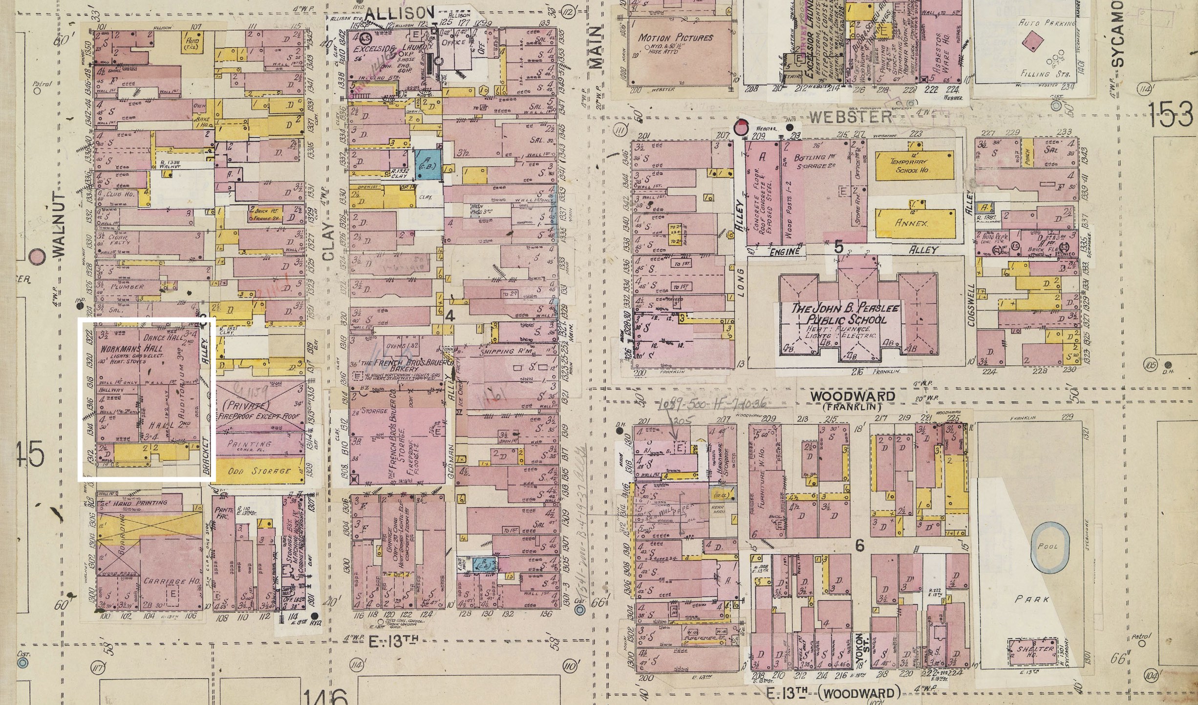
This map from 1904 includes the labels "auditorium" and "dance hall" inside Workman's Hall. In addition to being a meeting space for unions and labor organizations, Workman’s Hall was used as a social event space. A Cincinnati Enquirer article from 1895 describes a masquerade ball in the Hall held by the Superior Fishing and Outing Club which was attended by over 2,000 people. May Day events were held yearly on May 1st at Workman’s Hall, complete with speeches and musical and dance performances, as well as group singing and dancing. Theater performances were also hosted in the hall, such as a “Hobo Show” in 1912, which provided social commentary on the effects of automation on the working class. Members of the unions that owned stock in the building were able to utilize it for private parties and wedding receptions. Given its location in Over the Rhine, which was a German immigrant-majority neighborhood at the time, many of the events held at Workman’s Hall were bilingual, addressing the crowd in both English and German.
Image source: Sanborn Fire Insurance Map from Cincinnati, Hamilton County, Ohio. Sanborn Map Company, Vol. 2, 1904. Map. https://digital.cincinnatilibrary.org/digital/collection/p16998coll9/id/3464/rec/7.
1922
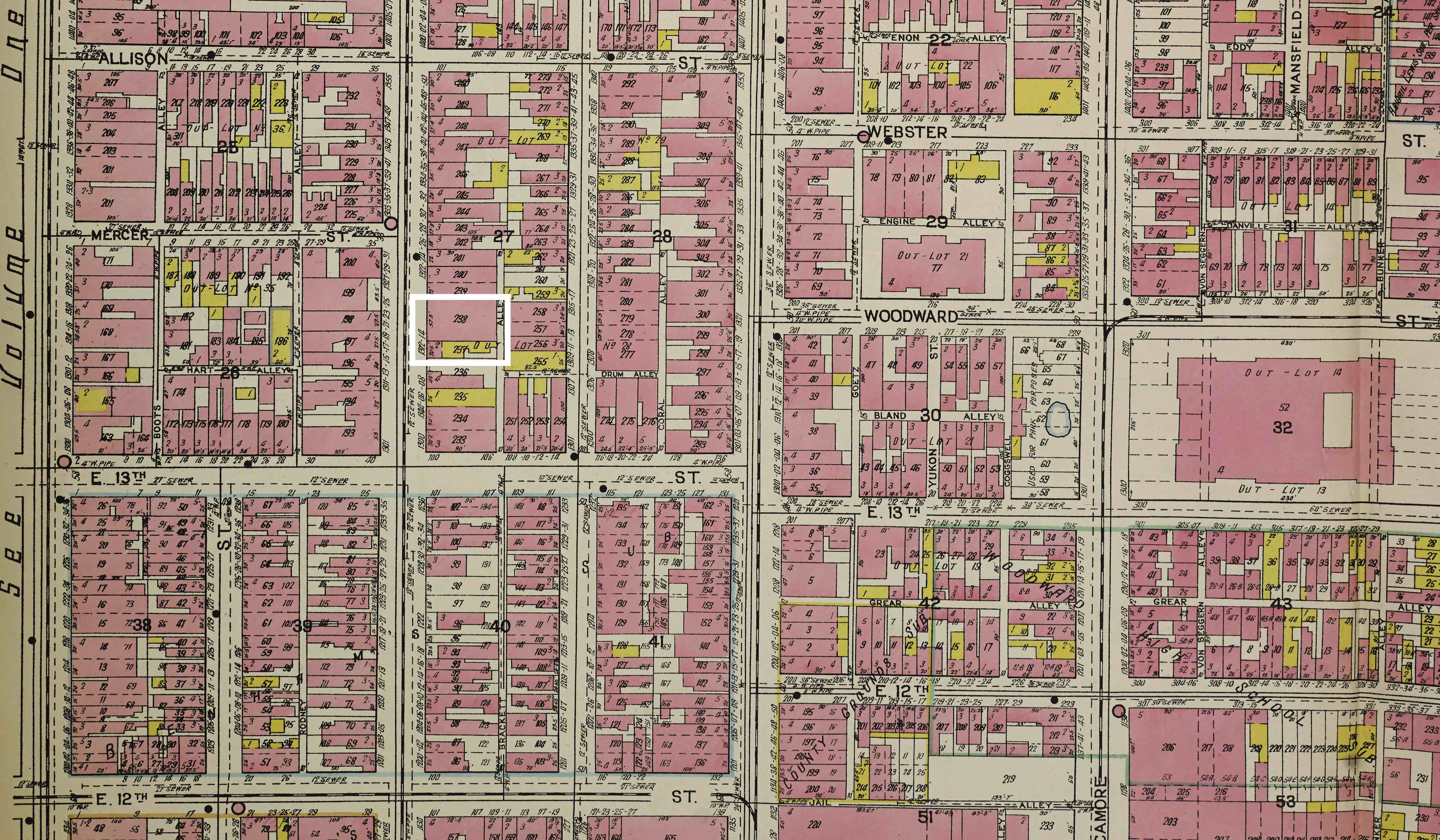
This map from 1922 does not provide too many descriptive details of Workman's Hall. Luckily, the Cincinnati Bookbinder's Union wrote a description of Workman's Hall — now called the "Labor Temple" — in 1920 that can help us visualize what the hall was like in this era:
“[The Labor Temple] is the largest establishment of its kind in the United States. In addition to five large auditoriums, there are several small lodge rooms, committee rooms, and offices for business agents. On the ground floor is a club room, one of the few in the world for organized workers. Here they have pool and billiard tables, a dance hall, card and checked tables, book shelves and racks for periodicals, shower baths and on the same floor a union co-operative store, where strictly label goods, soft drinks and cigars are sold… Now it is at last coming into its own, and Cincinnati will have a real Labor Temple— a real home for the workers— a place of welcome for the thousands of union men and women who will be coming to Cincy to attend the next world’s series— of 1920.”
Image source: Sanborn Fire Insurance Map from Cincinnati, Hamilton County, Ohio. Sanborn Map Company, Vol. 2, 1922. Map. https://www.loc.gov/item/sanborn06645_017/.
1937
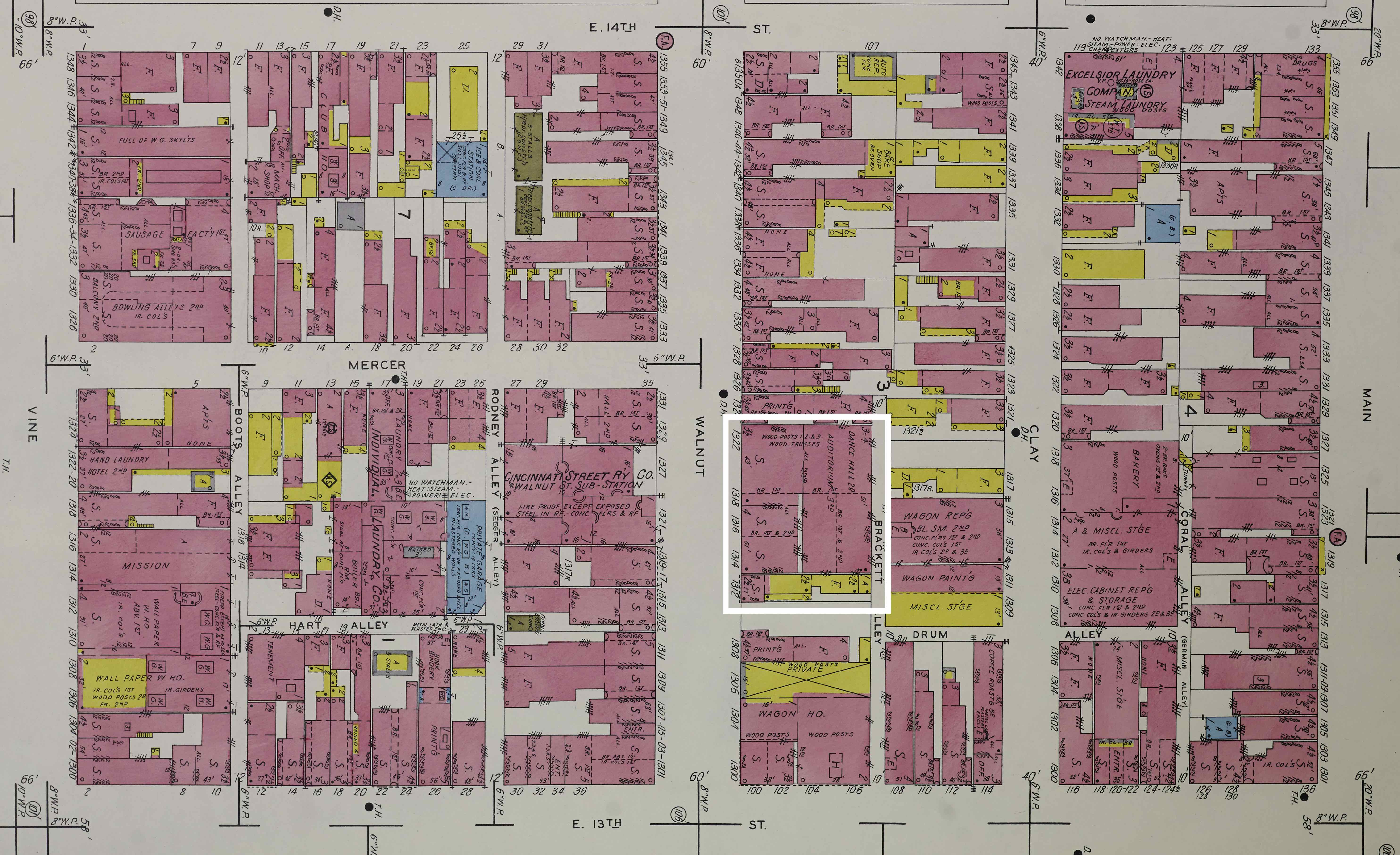
Throughout the 1930's, the Labor Temple continued to function as a meeting space for labor organizations as well as socialist and communist political parties. In 1932, the Cincinnati Post wrote an article recounting a speech given by William Z. Foster, the presidential candidate for the Communist Party. In a disparaging tone, the article reads:
"Into a poorly-ventilated third-floor assembly hall of the Labor Temple, 1318 Walnut St., Monday night crowded more than 300 'comrades' to hear William Z. Foster, presidential candidate of the Communist Party, berate Republicans, Democrats, and Socialists with equal fervor and bitterness. Foster, coatless and tieless, looked down upon an unusual crowd. Negroes and whites were crowded together in the disordered rows of wooden chairs; children, black and white, played in the aisles; all bothered by the sticky heat, but all jubilant." Foster criticized Hoover's handling of the depression and the U.S.'s participation in WWI. He warned that the "iron wall" being built between the U.S. and the Soviet Union signalled the possibility of another great war instigated by the capitalist nations against Communism.
Image source: Sanborn Fire Insurance Map from Cincinnati, Hamilton County, Ohio. Sanborn Map Company, - 1937 Vol. 2, 1934. Map. https://www.loc.gov/item/sanborn06645_019/.
1950
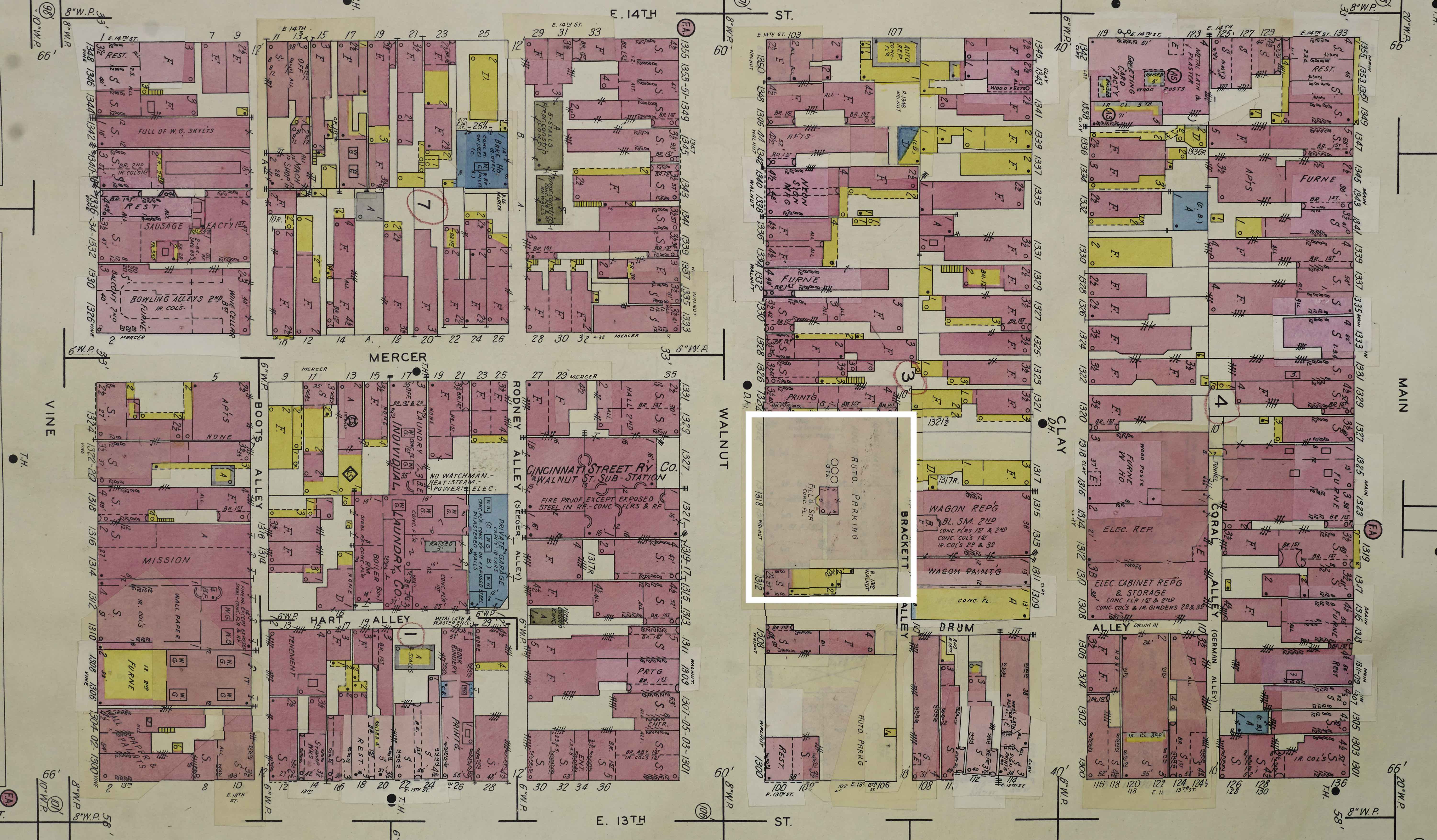
This map depicting the area around Workman's Hall in 1950 was modified from the 1904 map by the Sanborn Map Company. The company would update older maps by pasting pieces of paper reflecting changes in the urban landscape on top of older maps. The edits made to this map show that the building at 1314 Walnut St. which once was Workman's Hall has been torn down and the land has been converted to a parking lot.
Image source: Sanborn Fire Insurance Map from Cincinnati, Hamilton County, Ohio. Sanborn Map Company, - Jun 1950 Vol. 2, - Apr 1950, 1950. Map. https://www.loc.gov/item/sanborn06645_025/.
❮
❯


